As it was a fine evening, I decided to go out for a few kilometres on the canal to try to find a geocache with the children. We set out from Abbeyshrule village to give ourselves a reasonable length of walk as the cache was supposed to be up around Bog Bridge.
We had a fairly uneventful walk along the canal aside from a bit of a stop for the children to pet a pony. The blackthorn is starting to flower in places so we’ll have a riot of white hedges for the next couple of weeks.
We managed to keep up quite a pace, probably due to the exciting nature of our mission. Once you get a couple of kilometres out of Abbeyshrule you are in proper bogland.
We got to Bog Bridge and according to my phone still had a few hundred metres to go. This is a particularly remote area due to the bogland. We found the location thanks to the good description on the geocaching website.
We wrote up the notebook and took a couple of pictures before setting off back. It was a fair distance out of Abbeyshrule so we managed 7.5 km
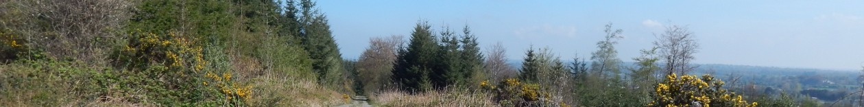
Got out for a fairly normal lunchtime walk today. The place is looking fantastic with gorse blooming everywhere but not a lot else is particularly active at the moment. The trees all seem to be a week or two late.
We made reasonably good time on the walk covering the loop in about 50 minutes.
I came across some info about the Siabh An Iarainn walking festival up in Drumshanbo and I figured this would be a good opportunity to get up Sliabh Aniarainn. So I got myself to Drumshanbo and joined the group for a quick bus trip to the starting point. We were a rather large group of 38 as two walks had been combined but everyone seemed reasonably well organised.
We joined a rough trackway up the western side of the mountain and quick soon we had spectacular views over Lough Allen.
It quite quickly became apparent that we were a group of fairly mixed abilities as the pace was quite relaxed and we had a couple of stops almost immediately. Still, it was a novelty to be walking in a group and it was nice to not to have to bother with navigation.
Our organisers had been busy before the walk and had added a few new stiles along the route. This man was very proud of his handiwork. Not sure if has photographing the group or his stile.
As we ascended we came across flecks of snow and the mountain itself was covered in snow. The temperature dropped markedly and as we were going relatively slow, my jacket and gloves came out of my bag in short order.
We took a coffee break after a couple of hours in a nice sheltered spot. After the initial climb, the going got a lot easier and we began to make some vaguely reasonable progress. The snow made for some quite specular photographs when combined with the clearing skies.
As we crossed the ridge we started looking for somewhere for lunch out of the wind. The views were really quite fantastic at this point.
After lunch, we headed off for the trig point which is on an island in the middle of a bog. We managed to get on to it with relatively little trouble but there wasn’t much of the path left by the time we’d got 38 people past.
After the peak we started heading along the ridge to big to make our descent. We split into two groups after about a kilometre and while I would have loved to continue on the longer walk, I was under time pressure and so bugged out for the quicker return. On the way down we passed a rather isolated mass rock.
This is was in a massive crack in a sheer rock face.
After this, it was a relatively short scramble down and across a very rickety bridge and we were on a track that used to be a road down the mountain. The bus picked us up at the bottom of this and it was back to the hotel for some soup and sandwiches.
It was a good relaxed day’s walking with some fantastic views and it was a nice stress-free way to get up Sliabh Aniarainn with somebody else doing the navigation.
It was a quick lunchtime walk with just me and the dogs along. We’ve had a great run of weather since last weekend so it was really pleasant if not absolutely scorching.
As I got further around there were quite a few things coming into flower. The bilberries have just got going with promise of delicious berries later in the year.
I should know what this white flower is but it escapes me at the moment. Anyway, it’s bringing a spot of variety to the greens and browns of the forest.
The last walk of my long weekend was a planned 15 km trip with my son along the canal. We had a fantastic day for it with the sun shining from early in the morning. We got ourselves on the trail by 10:30 on a quiet morning in Ballynacarrigy.
I spotted this interesting thing flowering. I have no idea what it is but it looked quite pretty.
They have been doing more work on resurfacing the trail along this section and it looks almost completed. There was a man attacking some sort of road machine with an unfeasibly large spanner at one point on the trail.
Luckily enough, the new surface runs out around Emper before we got to the really remote bog section. I really hope they leave that part alone as it is such a wild place but I don’t think that is likely.
The incredibly odd bog bridge looms int he distance on this shot. At this point we were about a kilometre from it. We had one of the dogs with us and I decided that as we were some distance from a road, it was safe to let her off the lead. She took full advantage and ran about like some sort of lunatic for this section of the walk.
We took a breather at Bog bridge and we shared a bit of chocolate while I had some coffee. We still had Lily the dog running around and she entirely vanished at this point. We were about to look for here when she returned after having had a nice swim in a bog-hole somewhere.
So we packed ourselves up and left bog bridge behind us.
We headed on to Abbeyshrule where we stopped for another couple of minutes. Abbeyshrule was strangely empty of boats for some reason.
We headed on to the lock beyond Abbeyshrule where we had a quick lunch of tuna rolls and crisps. At this point we were down to about for kilometres left.
We quickly passed Allard’s, Guy’s and Molly Ward’s bridge to arrive at Fowlard’s bridge after about 4 hours total. It was a good weekend’s walking as I managed a total of almost 85 km over the five day break
I had promised to do Kilronan Mountain again as a recce for a potential group walk so we arranged to do it this morning as a nice second walk of the long weekend. In the end, we had eight people in our little group so it was an unusual experience for me to be walking with so many people. We started out from Keadew again on a foggy morning but there were strong signs of a great day to come.
Anyway, we quickly walked out of the fog as we ascended quickly into the hills above Keadew. There were loads of horsetails about doing their equivalent of flowering.
As we got higher and out of the fog, it quickly got a lot hotter and before long we were shedding coats and fleeces before leaving the road for the steep muddy ascent up Kilronan mountain proper.
From here it was a quick ascent to a bunch of communications antennae and below those there is a very easily accessible sweathouse right on the path. So I took the opportunity to have a quick peek inside.
It was an interesting arrangement – a little over two metres tall to the centre of a vaulted ceiling where there was a small capped chimney. It was a bit over a metre and a half wide at the bottom.
There was a most amazing view across to Sliabh Aneirann where we were looking over the fog that was still lying in the valley. It almost looked like a sea over the land. The lower-level fog took another hour or so to clear after this.
We climbed higher and came to the point where the trail to Arigna splits off from our route. We had a sit down and a snack here and were just about to head when a pair of walkers caught up with us. They were amazed to see such a large group out on the mountain, so we had quite a long chat before heading our separate ways.
We got moving again and headed towards the wind farm on the peak. It was quite slow going as several of our group were wearing runners which were not idea in the rough and wet ground. Still we made it in a reasonable amount of time.
Being so close to the wind-turbines has kind of an unearthly feel about it especially in such bright sunlight when the shadows were sweeping across the ground. We had to walk along about 5 of them before the path returns to the rough heather ground.
The route holds high moorland before descending back a bit and into some forestry.
We then headed into the forestry which was extremely wet and trudged along for a kilometre or so before emerging into an abandoned mineworks.
After a short poke around we had about a kilometre on road before turning to the left along a track. There is a waymarker missing for this turn but it is pretty obvious on the map. After another kilometre or so, the track we are on heads downhill and we leave it – again at a point where there is a missing waymarker. This is where we went wrong the last time.
It is a pity I missed this section the last time as it is quite spectacular especially in the fine weather. There is a very basic track through the heather but this obviously isn’t walked too much. This section passes a saint’s grave where we took another quick break.
From here it is about 500 metres to the track where it regions the Miners’ way properly. This track leads us off the mountain and we begin to pick up the pace a bit. We stopped for lunch at a little bridge after about 15 kilometres.
We haven’t been making great time so far but after a bit of food and a change of socks for those with wet feet, our energy level picks up. We pick up the pace and start making close to 5 km an hour. At this rate, it takes little more than an hour to make Ballyfarnon.
With Ballyfarnon behind us, we have about 6 km to go through the Kilronan castle estate. I didn’t bother too much with the camera in this section as this is my second time here this weekend. I did take another shot of the rather fabulous ruined gatehouse of the estate.
We finally made it into Keadew after almost 8 hours. It had been a grand day out. I’ll mark this one up as 26.5 km as I forgot to start my tacker for a few hundred metres.
We got out for a family walk today and it was a really pleasant trip around the forest. The air temperature has really increased over the last few days and there are definite signs of things livening up a bit.
Some of the frogspawn has long since hatched and the eggs are well into tadpole stage. They are all swimming around nicely eating anything in sight.
There are so many varieties of willow catkins about. The detail in them is really pretty if you can be bothered to look in detail.
It was quite a slow walk today for various reasons but in the end we got around. We have this lovely stand of primroses growing in a ditch on the edge of our field
It was a nice trip round the forest in fine dry weather.
It was back to the Miners’ Way for me today and the plan was to get the southern section done. I had a slightly late start at 9AM and the plan was to get the train from Boyle at 6:30. So I started out at the the bottom of the hill from the Mining Experience.
From here, it was a quick climb up to the hills above Arigna and then heading south towards Keadew. The morning was still quite misty so Sliabh Anierin remain elusive as ever.
From here it was a couple of kilometres until the route branches off for the Kilronan mountain loop. I passed this and started heading down towards Keadew after passing the political cairn from my last visit.
I came across this odd little chamber under a communications mast on the way down the hill. I didn’t really have time to go poking around in it so I satisfied myself with a picture.
There is nothing on the map at this location but given the prevalence in the area it must be a sweat house.
After a steep and slippy descent down an old track, I got onto a local road and from here it was an easy walk in Keadew.
Keadew was really only just waking up. There were a couple of shops open and a bus arrived while I was walking through. A runner sneaked up on me and scared the bejesus out of me as I was walking through. I went up past the church and then down to Lough Meelagh.
It was at this point that I made a rather stupid navigation mistake which in fairness I had also planned. Because the walk is on two map sheets and the sheets are offset at this point, stupidly liked up the wrong parts of the walk and so headed off towards Ballyfarnon instead of turning left directly towards Keadew. I think this error ended up adding about 5 km to my route. Anyway, I headed on towards Kilronan Castle and entered through these rather fabulous gates.
I continued on merrily through the forest around the lake completely oblivious to my own stupidity and made good progress towards Ballyfarnon which is a lovely little village. After passing through Ballyfarnon, I headed up a hill and got ready to leave the roads behind me for a bit. It was at this stage that I started getting the niggles that something was wrong with my direction. Sure enough after getting both map sheets out I realised my error and turned around.
So after a rather fast 4 km hike back along through Ballyfarnon and down a road along the western side of Lough Meelagh, I got back on the correct route. This episode added about 6 km to my journey. Once back on the right route, I swapped out my map sheets and set out again.
The route followed minor roads for a couple of kilometres before switching back to muddy tracks and then going across fields for a while. As I was nearing the 20 km mark, I decided to stop for lunch at this stage.
After lunch, I continued across fields and got the first glimpse of Lough Key. Boyle, my destination is on the far side of the lake. I descended towards the lake and joined a busy regional road towards Knockvicar at an interesting crossroads which had two pubs – both closed due to Good Friday.
I made good time along the main road which was a bit unpleasant before I got to Knockvicar which is a nice little village with a rather substantial bridge across the Boyle river.
The route carried along the main road for another few hundred metres before turning off into a nice little amenity walk on a mostly cut-away bog.
There was some interesting fauna in a field along this route. I think these are alpacas which aren’t terribly common in Ireland
The route looped around through bogland, bluebell woods and along the shores of Lough Key and it was a very pleasant section. I stopped for a bit of a chat with a local walker for a couple of minutes.
I was looking out for a spot to sit down and have a coffee as I was starting to get quite tired. I found this nice spot with a view onto the lake so had a quick break.
The route meandered through forestry and we eventually ended up in what would have originally been land belonging to the Rockingham estate judging by the rather substantial walls and the odd castle in the forest.
Not long after this, the route emerged onto a minor road through open farmland that would have once been open parkland belonging to the estate. This was turning into a bit of a slog as I was noticing that I was getting very tight on time for making the 1830 train.
All of the bridges on the old estate have a very distinctive style. Once I was across this, I had a couple more km to go to make it to the forest park. I entered the forest park through a back entrance into the carpark.
After going through the car-park, I got a nice view of the lake and stopped briefly to use the facilities before getting back on the trail. At this point, I was getting extremely tight for time and I didn’t know which route the waymarking would take me through the park.
Needless to say, it sent me on the most roundabout rote possible, and I wasn’t going to take a short-cut in case that ended up being even longer.
This castle in the middle of the lake is actually a folly and is built to about 70% scale of what it would actually be. I went out there on a boat a couple of summers ago and it is in a pretty bad state of repair.
I struggled on, making quite a good pace – I rattle off an 11 minute kilometre at one point but I really was feeling the pain of a long day’s walking and so regretfully had to call a halt to proceedings after passing through the rather dramatic entrance archway to the estate.
I made a total of 38 kilometres for the day, but I had to call a taxi at this stage as I had about 2.5 more kilometres and about 25 minutes to make the last train of the day.
After a really wet couple of days, I was somewhat surprised to see the rain more or less completely stopped when I went to go out at lunchtime. It’s been a few days since I’ve been up the top due to a long walk last weekend but not a lot has changed.
One slight change is that there is something now flowering even if it is a bit drab. I can’t remember what these are but they are pretty abundant through the forest.
It will probably be a while again before I get up there as I have a few long walks planned for the Easter weekend.
342.5km
Walking forests and trails in the midlands of Ireland