I’ve been a little lazy with walking over the last couple of weeks due to trying to get on top of the garden a bit and I’ve rolled a few walks into a single blog post as to be honest the posts about Ardagh mountain are getting a bit tedious the second year around.
Anyway, the flowers are getting a bit less monochrome with a bit less yellow and a lot more blues, pinks and purples as the year eases on.
We’ve had a couple of weeks of dry weather which is a nice change. The orchids in our bottom field have started to flower. These really are quite spectacular.
So I’ve managed four walks over the last two weeks which is a bit slow by my usual standards but the plan is to make it up with a canal trip this weekend.
I found myself in Ballyfarnon at about 8:30 on a Saturday morning putting my boots on for my last section of the Miners’ Way which I’d planned as a 35km section from Ballyfarnon through Castlebaldwin and on to Boyle. It was a fairly fine morning – overcast but dry.
As I was setting off, a group of cyclists stopped for a break and we exchanged greetings. I got myself moving and soon left the village behind without much fuss. For the first time in ages, I had very little ground to cover again. After about a kilometre I passed the junction between the two sections and was on virgin territory again.
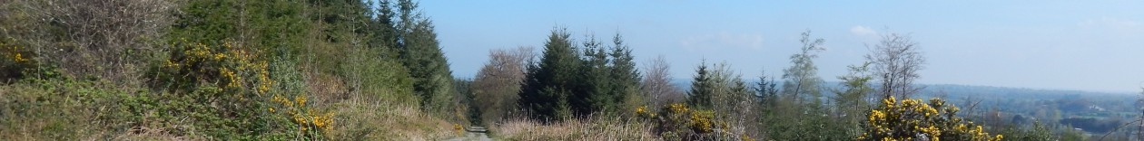
There are quite a few lakes in the area but the main feature of the walk for the day was to be Lough Arrow as the route essentially does a massive loop around the lake. The lane I’m walking gets progressive narrower and greener until it turns into a lovely little green road.
There is a really striking purple flower that does really well in this area and looks a bit like a hyacinth. They seem to be quite widely distributed on verges in the general area.
I continue on this green road for a bit – the route around here is quite hilly and there is quite a bit of up and town. However, the going is easy – all of the route is on roads or dry tracks and there is little opportunity to get wet feet. Indeed a good part of the first few kilometres is also marked as a cycle route.
A bit further on the route drops down past an interesting looking outcrop – the landscape is quite rock.
After this the route wends its way between two little lakes – White lough and Black Lock. White lock is first and opens out over a relatively flat shoreline.
Black lough is the opposite with cliffs on one side and all the banks very steep indeed. The surface of Black lough is mirror-like in its stillness.
After passing these I have a sudden climb to contend with which leaves me quite out of breath. This day is going to have a lot of upping and downing before I’m done.
As I head further south the landscape becomes a bit odd – there are a lot of glacial erratic boulders on the ground and some of these are truly massive. In the area where I live there are quite a lot of these as well, but they are generally buried and you’ll only discover them when you try to remove a stone from the lawn and then find out your dealing with a 10 tonne rock.
The route leaves the road for a kilometre or so while it ascends a small hill with a trig point on top. There are clear views from here about 30 or 40 kilometres to the northwest and to the south so I guess is a good spot for a trig point.
From here I descended onto a road for a bit and then back off road for a couple of kilometres before I end up in a hotel carpark. On the way the route passes this rather fabulous dolmen.
This is a really impressive site and is associated with the legend of Diarmuid and Gráinne. I had a cup of coffee and a snack here and rested for 5 minutes before pushing on through the forest and towards Cromleach Lodge and on towards Arrow river which the route crosses at the very head of Lough Arrow.
A few hundred metres after this, the route takes a short-cut across some fields and it is a quick couple of kilometres up into Castlebaldwin. There was a large road-house type restaurant here that serves food all day and I was very tempted to stop and have a hot meal. However, it was just a little early to be taking a lunch break so I pushed on towards Carrowkeel.
This route was quite interesting and we took a detour through a donkey sanctuary before heading up into the hills towards the Carrowkeel Megalithic Tomb. I pushed on for an hour or so beyond Castlebaldwin until I was well past the 20 km mark and could stop for lunch confident I had more than half of the day’s walking done.
Suitably refreshed after a lunch of ham sandwiches and crisps I headed up between the two rocky ridges and into a rather fantastic landscape. You can see the ridge on the left from the main road but the one on the right is really striking as the cliff-face on it continues on for about 4 kilometres.
After about 20 minutes, I came to a sign where the route splits from the path to Carrowkeel. I really wanted to take a look but it was marked as a kilometre off the route and I didn’t really want to add two kilometres to my day.
This terrain continued for a couple of kilometres before I descended into a valley and back up the other side of one of these ridges
Amazingly there was even a ruined cottage up here. Talk about living in the middle of nowhere.
At this point I started descending into a valley. This went down a lovely green road and past another couple of ruined cottages. Before long, I joined paved road for a couple of kilometres before heading off up again into the Curlew mountains.
This is the view from down the bottom looking back up towards the ridge.
At this point the rain that had been threatening all day got serious about things and I ended up putting my camera away so I only took a couple more shots with my phone. The route headed off through a forest road which was quite seriously littered with old beds and sofas.
With about 4 km to go, I joined the old N4 road which is now a country road since the Curlew Mountains bypass was built. The route has an off-road path here since this used to be such a major road but the terrain is horrible and I probably would have been better off sticking to the road.
The route started off reasonably well with forest track and well-made wooden bridges but then deteriorated badly into a hack across forest drainage channels and then a mixture of ankle sucking mud and moss. It emerged from the forest and then across some moorland with barely a hint of a track aside from the waymarkers. This two kilometres took me nearly 45 minutes to traverse which I could have done without.
I was seriously glad to emerge onto a road from where it was a simple couple of kilometres down into Boyle town where I took a taxi back to Ballyfarnon to pick up my car. All in all, it was a very successful day’s walking which completed my Miners’ Way.
For my lunchtime walk, I decided to run the loop as it started pouring with rail almost immediately after I set out. It wasn’t terribly wet but I didn’t want to end up needing a shower.
The vegetation has taken on a distinct summery flavour and the cow-parsley is flowering as the nettles and grass really get going. I didn’t really bother with much else along the lines of photography.
As my dad has a new mobility scooter we wanted to find a good spot to take him for a wander and Coolnahay came to mind as it has a good solid path and not too many obstructions. So we set off for a wander on a fine May afternoon.
Oddly enough, for a place that normally has so many people about it was quite deserted. Still it was a lovely peaceful time. Conscious of the range of the scooter we turned round at about 4 km although if I’d known how close we were to Ballina we should have gone the rest of way.
There were loads of cowslips around – they seem to do really well in the undisturbed grass. When we got back to Coolnahay we came across an interesting sight – a racing pigeon was having a rest on the bridge.
He was really tame and came right up to my daughter. That was a nice end to a nice relaxing walk.
I managed to get out twice today – once at lunchtime and once in the evening with the children who needed a bit of exercise. We managed to dodge the heavy showers we’ve been having for the last few days so had dry walks both times even if the ground is very wet.
I christened a new pair of boots today – my old daily walking boots had given up the ghost after about 5 months – I won’t be buying Hi-Tec boots again. The Lidl ones I had before as daily boots were better.
The pine flowers are now well on their way to becoming pine cones. I really love this time of year in the forest as everything is coming alive and there is a real sense of possibility. The bilberries are coming along nicely – there could be a good crop this year.
We all went for a walk in Derrycassin to see the bluebells but unfortunately I forgot my camera. The didn’t fail to disappoint and we had a lovely walk among the blue mist.
I nipped up the mountain on a fine Saturday afternoon to get a quick walk in. There is loads of stuff flowering at the moment which makes for quite the spectacle.
There isn’t really a lot to say about the walk – it was a fine day for it.
Although not a part of the forest, the apple trees in my garden have rather fabulous blossoms at the moment.
I was back to the Miners’ Way for the day and although I planned on getting the bulk of the remains of it done, the weather had other ideas. But it started out OK. I left Arigna village at about 08:30 and started on about a 5km walk-in to my starting point on the loop itself. I didn’t follow the official route as that would have given me at least twice the distance back-tracking and I wasn’t really up for that.
The weather was overcast but dry – perfect walking conditions really even it was a bit misty. The initial couple of kilometres was easy enough going with a gradual incline taking me up into the hills. I did spot this rather fabulous horsetail on the side of the road.
After a couple of kilometres, I turned off the road I was on and started heading up into the hills properly. This was quite a steep climb but the views were kind of worth it.
I came across this lovely thatched cottage but it wasn’t long before I left the houses behind. Although the Irish love to build everywhere, once you get into the proper uplands they tend not to bother so much.
As I headed up the hill, the windfarm on the mountain starts to loom overhead and there is a low rhythmic swoosh as the nearby turbine is turning fast in the stiff breeze. These turbines will be a major feature of the walk as the route takes me right around them. A lot of people complain about them, but they are a lot easier on the landscape than the coal mining that went before them.
As I crest the mountain, I got a fabulous view of Lough Allen although it is somewhat obscured by mist. Sliabh Aniarainn is hidden in clouds as usual.
I get a bit of a break from climbing and the route flattens out for a kilometre or so until I rejoin the Miners’ Way properly at a ruined house where I took a break for lunch on my walk from Dowra to Dromshanbo.
One of the slightly unfortunate features of the Miners’ Way is that it is very difficult to complete it without covering parts of it two or three times. So with this in mind, I backtracked along the route to towards Dowra for another kilometre until I came to the branch point.
And yes, the marks on one of the sign do appear to be from shotgun pellets.
I took the turn and started heading off up towards what is probably the wildest bit of the walk I’ve seen so far. This part of it follows an old quarry road and ends up in the wind-farm. All around are various rock faces and piles of earth that are the result of previous mining.
You get a real sense of this being the Real Miners’ Way. There are a few other industrial highlights, but none of them seem quite so isolated and in such an unlikely place. When you get to the top, there is this strange expanse of gravel – it is hard to know if this old or if was excavated when they were putting up the wind-farm.
By now, it was starting to drizzle a bit but nothing too upsetting. I started down the access road for the wind-farm for a bit until the route turned off across a bog before heading down the mountain. This was to be a bit of an up-and-down day as the route took me up out of Arigna, then down into the a valley before going up Kilronan Mountain. So I went down across the bog, then through some cut-away forestry that was probably really nice a couple of years ago.
After crossing a road, I took a coffee break before continuing down a lovely grassy road through a forest. This looks like it used to be a proper road as it ends up in ruined cottage.
This would have been a nicer spot for my coffee break but no worry – I continued downhill until I came to a rather substantial river with a fairly new steel bridge across it.
From here I headed up through the forest until I came to another track that used to be road.
This took me up by an old ruined school that obviously had a very short operational lifespan since it was only built in 1955. It was in a pretty sorry state.
By now the rain was starting to get a bit serious about things which was making life a bit difficult.
I followed the old road up for another hundred and fifty metres or so and came across a nice little church and grotto.
Then I followed the road for a bit before the route headed off into another patch of forestry and steeply upwards towards Kilronan mountain. By now the rain was getting quite bad and I had to put the camera away as it was really getting quite wet. So of necessity there will be little more photography.
It was a pretty steep climb up the side of Kilronan Mountain but it was all over quite quickly and the route followed a a contour for a couple of kilometres. On a better day there would have been a fabulous view here but there was nothing much to see today unfortunately.
Futher on, there was a bit of karst landscape with an exposed area of rock. On this I spotted some lichen in spore which added a vivid splash of colour.
By now the rain was really getting quite nasty and the wind had also come up so I was getting really soaked. I started to think about bailing out since there was little point in walking for another 4 or 5 hours in this. But since I was in the middle of nowhere I still had another hour or two to get to somewhere that I could get collected.
So I struggled across the exposed moorland until I came to a track which started bring me down towards more sheltered ground. I quickly joined up with the Kilronan loop by which time I was recovering ground I’d done before.
Down by the bridge where I had lunch on another walk I came across this rather pretty purple bluebell and there were a few more along the bank here. At this point it really started bucketing rain and I decided to give up on my day’s goal and just head for Ballyfarnon. I’m not going to bother with a detailed description of the remaining 4 kilometres of road walk as I’ve done it twice before.
It wasn’t the most successful day’s walking but I still managed almost 25 kilometres and a reasonable amount of ascent so it wasn’t too bad. All that remains of the Miners’ way is about 25 km of relatively accessible route between Ballyfarnon and Boyle so I’ll have to return another day.
After having been a bit lazy the last time I was working from home, I went out into the rain for a lunchtime loop. It was a bit wet for most of the walk to be able to use the camera. All I managed to take in the line of photographs was this broken blackbird’s egg.
Anyway, we got a walk in despite the weather so that must be a good thing.
For a bit of a change we went over to Derrycassin woods which is a nice spot in north Longford. The weather was reasonable enough although it was threatening to rain.
The big feature here at the moment is the bluebells which are a couple of weeks ahead of the Ardagh woods ones for some reason.
We had a grand walk – Derrycassin is very easy going with good gravel paths for the most paths and the rest of the paths are on dry spots so you don’t stand any real risk of getting wet or muddy. The bluebells aren’t quite peaking yet – they’ll be another week or so.
513.5 km
Walking forests and trails in the midlands of Ireland